These articles are now archived and will no longer be updated.
New data from Swansea University has showed that the bushfires raging in Australia are likely to pollute air quality over a very wide geographical area and could have a long term negative impact on public health.
Peter North, Professor of Geography in Swansea University’s College of Science, has developed the atmospheric retrieval from satellite images with colleagues Andreas Heckel and Dr Kevin Pearson, supported by the European Space Agency Climate Change Initiative.
The fires, which have burned an area of 10 million hectares in Australia in this fire season, or approximately five times the area of Wales, have followed the hottest and driest year on record for Australia and the second hottest year globally.
The team found that the dense plumes of smoke from the bushfires blanketing South Eastern Australia have travelled over 4,000 kilometres over the Pacific Ocean and New Zealand.
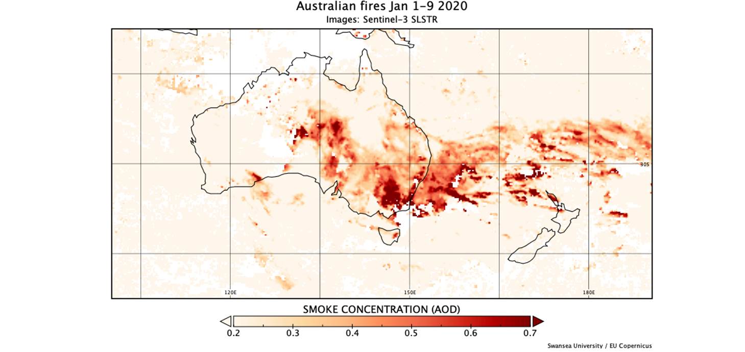
They also looked at the total column smoke density which is given by Aerosol Optical Depth (AOD), a measure of interception of sunlight, and found that while typical levels are normally under 0.2 for Australia, the satellite images shows half the continent far exceeds this and rises to more than 0.7 for large areas.
Professor North said: “It has been estimated that 3.7 million premature deaths worldwide annually are due to high concentrations of particles that circulate in the atmosphere around us, and these can come from sources such as urban pollution, mineral dust and wildfires. The data we retrieve from studying these satellite images are important as they can help us to give early warning of air quality hazards that result from these wildfires.”
The images of the area came from the Sentinel-3 satellite, which is part of a fleet of dedicated EU-owned satellites, designed to deliver operational information to the European Union's Copernicus environmental programme.
The satellite system is designed to provide reliable images even over bright land surfaces such as Australia, which are difficult for most satellites and researchers were able to see smoke transported over desert regions, as well as plumes arising from fires in Tasmania and Western Australia.
The operation and development of the Copernicus Sentinels are undertaken jointly by European Space Agency (ESA) and the European Organisation for the Exploitation of Meteorological Satellites (EUMETSAT). Swansea University are working with EUMETSAT to give rapid delivery of aerosol images needed for improved air quality hazard warning.