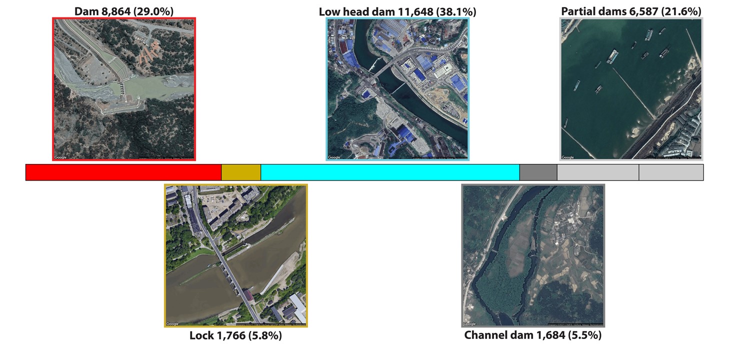
Examples of what the different infrastructure types (Dams, Low head dams, Locks, Channel dams, and Partial dams) documented in the Global River Obstructions Database look like in satellite imagery along with the number and percentage of each at the global scale.
A new spatial database of dams and other river obstructions built partially or fully across the world's largest rivers has been published.
The Global River Obstructions Database (GROD) supports the Surface Water and Ocean Topography (SWOT) satellite mission led by NASA, CNES and Canadian and UK space agency partners to improve ocean and surface water topography measurements and determine how water bodies change over time.
The database, and the approach to pairing people and computing power used to create it, came together over five years with contributions from several dozen researchers, students, and volunteers from Wales, the United States of America, the Netherlands, and Canada.
Using publicly available satellite data from Google, the team were able to manually identify dams and other river obstructions.
Between 2018 and 2021, the team mapped 30,549 human-made structures obstructing river flow and estimates GROD to have captured more than 90 per cent of obstructions on major rivers wider than 30 metres.
This new dataset will provide vital information for researchers and decision-makers and is openly accessible to the public.
Swansea University academic Dr Stephanie Januchowski-Hartley, who helped conceptualise and fund the database as part of her Ser Cymru Research Fellowship, said: "In addition to assisting the production of SWOT data, GROD will support and foster new interdisciplinary studies that help us to better understand how these structures change and impact the hydrology and ecology of our aquatic systems."
Dr Tamlin Pavelsky, whose work as US Hydrology Science Lead for the SWOT mission funded the work at the University of North Carolina, said: "This database is different from other available dam databases because it is global.”
“It is directly tied to major rivers and contains both dams that create reservoirs and many structures that impact flow but do not impound significant amounts of water."
The launch of GROD has coincided with a new research paper published in Water Resources Research, with key findings revealing:
- Low head dams, also known as weirs, were the most abundant obstruction, followed by dams.
- Just 42 per cent of rivers studied are minimally obstructed, meaning they have less than one dam, low head dam or lock per 1,000 km of river length.
- GROD contains 8,864 dams, a substantially greater number than previously recorded in other global datasets.
Dr Xiao Yang, from the University of North Carolina who led the research, said: "The development of GROD demonstrates the ability to use the latest cloud-based platforms to efficiently facilitate collaborative mapping work, providing globally consistent information of human impact on our environment that would otherwise be challenging to obtain by compiling existing databases or relying on automated algorithms."
Global Dam Watch (GDW), an international collaboration between researchers passionate about understanding the costs and benefits of dams to our world, will host GROD along with other broad-scale river infrastructure databases.